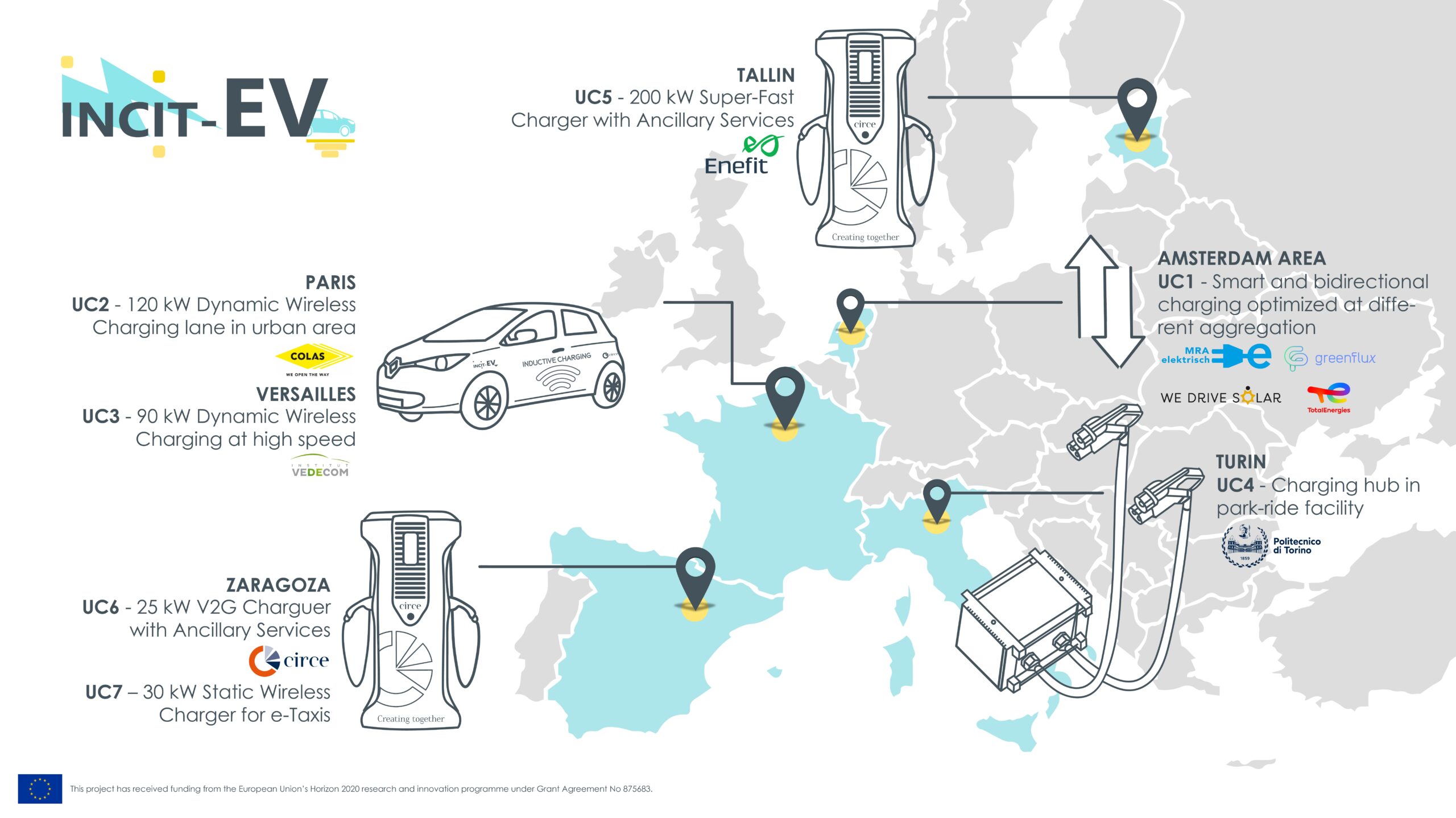
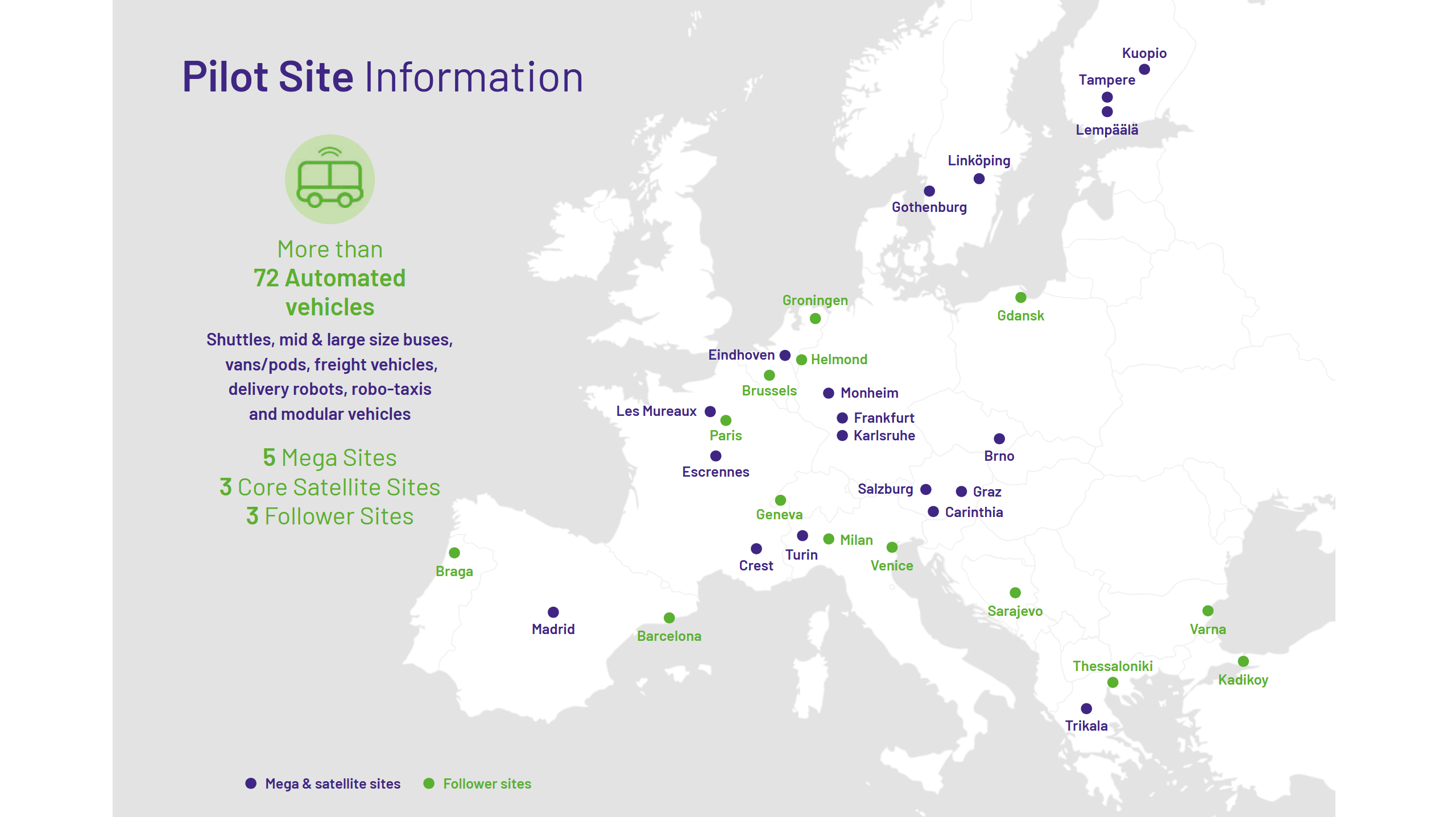
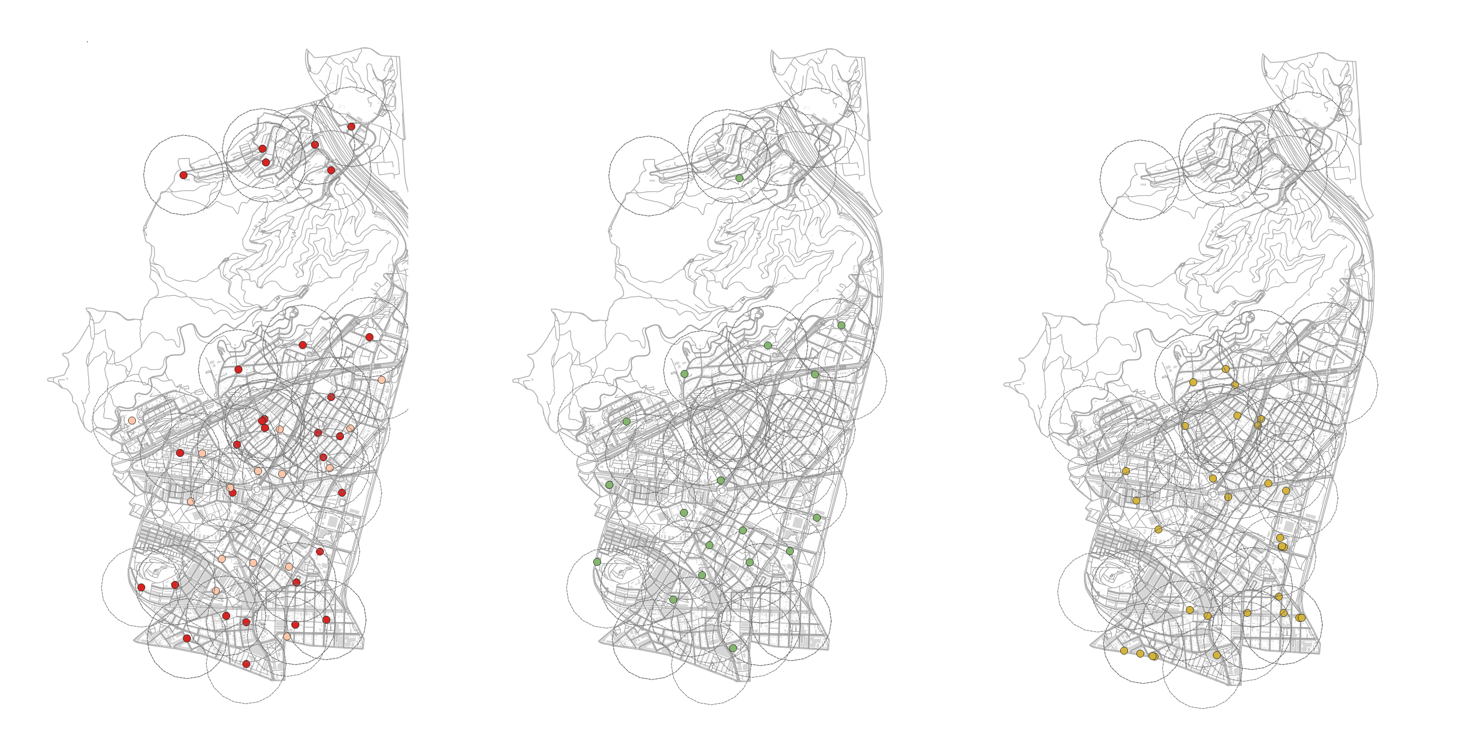
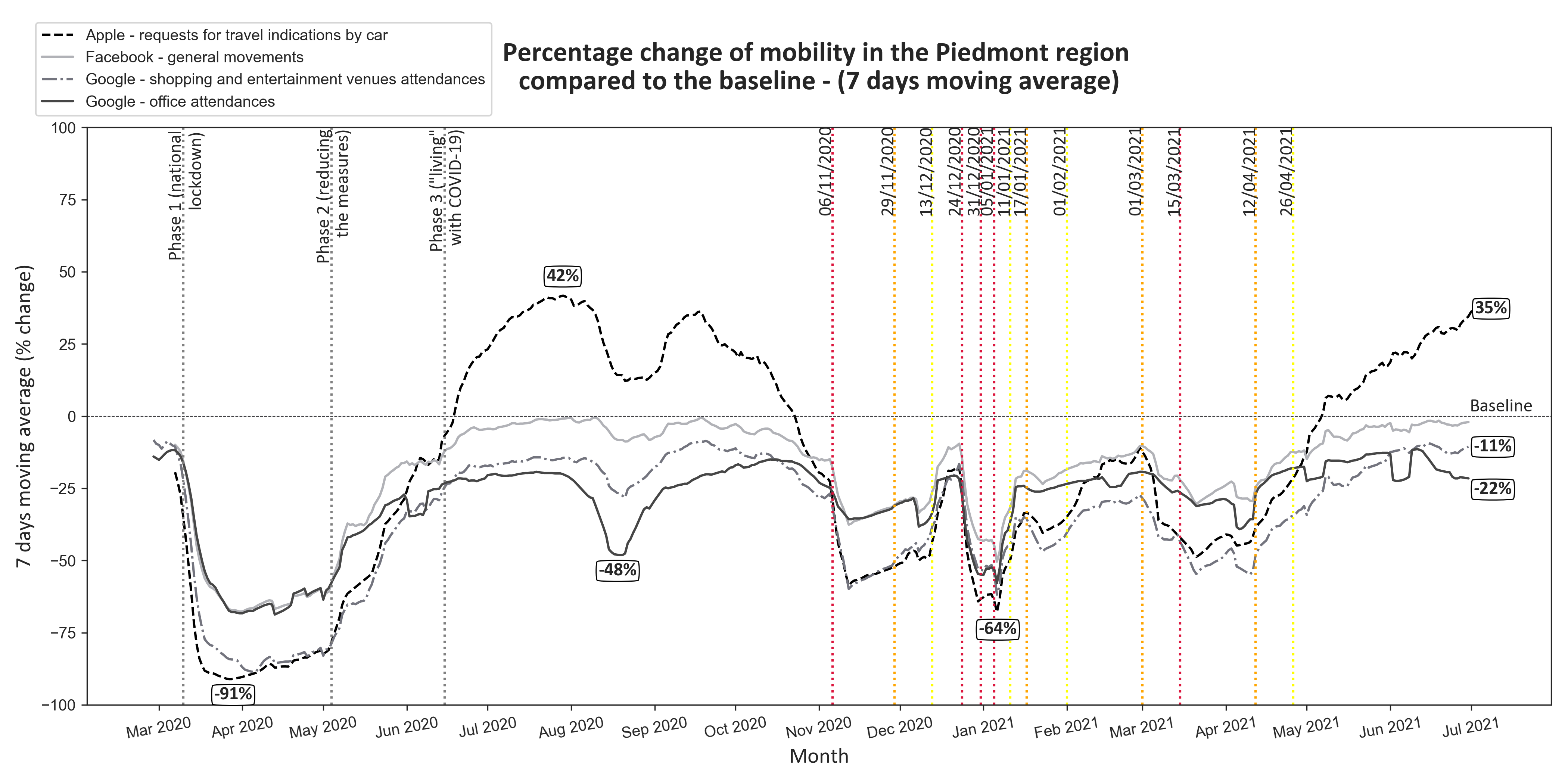
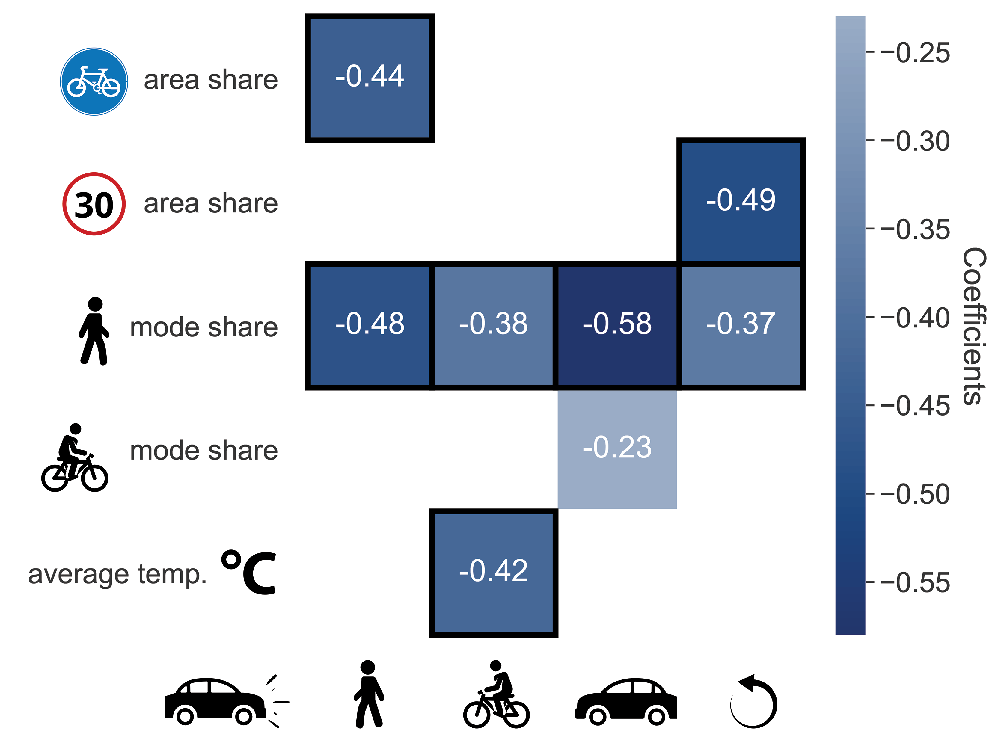
About

Making sense of complex data with visual stories that drive action!

Hi, I'm Marina!👋

I always liked numbers, order and organization. Most of all, I like creating, and I see data as a piece of scattered LEGO's that have to be put in order to make a story with an impact. 🧱

That's exactly what I do daily: I dive into big datasets of various types, in order to find insights that will help businesses and institutions in their decision-making processes. I'm skilled in all steps of data science process: from data collection and processing, application of statistical methods (including machine learning algorithms) to data visualization and results communication to various stakeholders. My background in Information Processing helped me build a strong technical foundation, with a particular focus on Image Processing. On the other hand, my student years and memberships in some student organizations thought me soft skills like public speaking, communication, negotiation, funding, teamwork and leadership.

Now, after 4 years in Urban Data Science field and a valuable experience at 2 Italian research foundations, I am ready to embark on a new journey. Although I am still very interested in continuing my work in fields mentioned above, I've been captivated by the idea of exploring additional paths, be it finance, healthcare or earth observation/ remote sensing, the allure of venturing into the unknown presents an attractive opportunity for my professional growth.

Currently, I'm expanding my knowledge and learning about cloud services (AWS, Azure, GCP) and model deployment and monitoring (Docker and Kubernetes), with an aim to become a Full Stack Data Scientist.

Fun facts:

  • I can make a conversation in 5 languages (🇭🇷, 🇬🇧, 🇮🇹, 🇪🇸 and 🇩🇪).
  • While studying for my MSc, I was the main organizer of an international student conference in the capital of my country and I managed to convince the President of the Republic to endorse it with high-patronage!

You liked what you just read? Great, now check out some of my projects!
You have a proposal for me or a project to work on? That's cool, let's get in touch!

DSS for EV Charging Infrastructure

Type
Public sector project: HORIZON EU (H2020) research and innovation action including 33 partners - INCIT-EV

Description
Between early 2023 and 2024, I was immersed in a compelling role as a Project Manager at a research foundation in Turin, where I contributed to a Horizon 2020 Research and Innovation Action project called INCIT-EV, involving a vast network of 33 partners. This project aimed to demonstrate an innovative set of charging infrastructures, technologies, and associated business models designed to improve the EV user experience.

My main responsibility was orchestrating the development of a cutting-edge Decision Support System (DSS) alongside two internal developers and two external partners, while also coordinating a Work Package consisting of 13 partners. The DSS tool was tailored to assist Mobility Planners and Policy Makers in crafting customized action plans to promote the uptake of electric vehicles in cities. By facilitating seamless collaboration and communication, my aim was to foster a sense of shared purpose among stakeholders, ultimately working towards a more sustainable future for urban mobility. In addition to the coordination activities, I also played a pivotal role in enhancing the tool's usability from the users’ perspective.

INCIT-EV
Fig. 1. INCIT-EV - Large demonstratIoN user CentrIc urban and long-range charging solutions to boosT an engaging deployment of Electric Vehicles in Europe

Read more
You can read more about the project on the official website. The Decision Support System (DSS) tool will be accessible to the public in the near future here.

Dashboard for Autonomous Shuttle Tracking

Type
Public sector project: HORIZON EU (H2020) research and innovation action including 69 partners - SHOW

Description
During late 2022, I was involved in a Horizon 2020 project called SHOW, which aimed to support the deployment of shared, connected, and electrified automation in urban transport, with the goal of advancing sustainable urban mobility. As part of the project, real-life urban demonstrations took place in 20 cities across Europe, integrating fleets of automated vehicles into public transport, demand-responsive transport (DRT), Mobility as a Service (MaaS), and Logistics as a Service (LaaS) schemes.

One of the demonstration sites was the city of Turin, where two autonomous shuttles operated in the hospital area along an authorized path of about 5 km. To drive operational improvements, I developed a Power BI dashboard for shuttle tracking in Turin, leveraging my expertise in data analysis and visualization.

SHOW
Fig. 1. SHOW - Pilot sites of the projects

Read more
I cannot share more details on the dashboard for autonomous shuttle tracking for privacy reasons, but you can read more about the project on the official website and also on the Turin pilot case.

Urban Data Analytics

Type
Personal project: result of a Global Summer School in Urban Data Analytics

Description
In July 2025, I participated in a week-long workshop "Image Based Analytics for Data Driven Mapping of Urban Vulnerabilities" by Institute for Advanced Architecture of Catalonia (IAAC) in Barcelona, which explored how digital innovation and urban analytics can create more inclusive cities by integrating citizens' needs into urban design. By using multiscalar datasets, specifically Google Street View imagery, open data and tools like QGIS, I analyzed the urban environment in one neighborhood of Barcelona (Nou Barris) and developed sustainable design proposals. I chose Nou Barris neighbourhood because of its':

  • highest rates of childhood obesity in the city (official ASPB data),
  • lowest income per capita,
  • known deficit in quality public space and sports infrastructure, particularly near schools,
  • politically under-prioritized situation in terms of urban renewal compared to central districts.

The data taken into consideration included:
  • Google Street View Imagery in order to assess the conditions and accessibility of parks and playground areas
  • Barcelona open data on socio-economic indicators, schools, open playgrounds and parks
  • Open Street Map data on fast food restaurants and similar facilities

The ongoing analysis in QGIS software showed how certain areas of Nou Barris neighbourhood are deprived of open playgrounds and parks, while flourishing with fast food facilities. Once finished, this page will be updated.

urban_data
Fig. 1. Map of Nou Barris neighbourhood of Barcelona and its' schools, playgrounds/parks and fast food facilities

Read more
The maps I created and data analysis code are available on my Github.

Post-Covid Mobility

Type
Private sector project: Commissioned by a local Trade Union in Italy.

Description
In 2021, as a part of a large-scale project evolving around the prediction of mobility demand in Piedmont, I analyzed the mobility behaviours in the region during and after the COVID-19 pandemic thanks to open data from Apple, Google and Facebook.

The data taken into consideration included:

  • general movements from Facebook (Movement Range Maps)
  • requests for travel indications by car from Apple Maps (Mobility Trends Report)
  • shopping areas and entertainment venues attendances; and office attendances from Google Maps (COVID-19 Community Mobility Reports)

Considering the period from March 2020 until June 2021, this analysis showed how mobility habits changed (at least temporarily), especially in the case of shopping, entertainment and office attendances where the % change was still below the baseline (-22% in the case of offices).

covid_mobility
Fig. 1. Percentage change in mobility in Piedmont compared to the baseline, calculated as a 7-day moving average. The 3 phases of COVID-19 lockdown are marked on the left half of the figure, while the other so-called "red", "orange" and "yellow" zones are marked on the second half of the figure. Baseline is an average value calculated based on a 5-week period in Janaury and February 2020.

Read more
Due to privacy reasons, I cannot share more information about this project, but the data analysis code is available on my Github.

Urban Road Safety

Type
Private sector project: A research project resulted with a published article.

Description
In 2019, I had the privilege of being selected as one of the top 8 graduates and was subsequently awarded an Applied Data Science Fellowship. This fellowship provided me with the opportunity to conduct comprehensive research on the relationships between road crashes and urban features. My tasks included analyzing relevant literature, collecting and cleaning data, performing statistical analyses, and utilizing machine learning algorithms to gain insights into the complex interplay of road crashes and urban characteristics.

Following the OECD's recommendations for a modern road safety approach and employing casualty matrices, I systematically examined crash causation in 24 European cities, identifying cars as the predominant threat, with variations observed across different urban environments. Further analysis of urban features, including population density and infrastructure, revealed a noteworthy correlation: cities with higher pedestrian presence and lower speed limits demonstrated fewer casualties (see Fig 1.). While acknowledging potential reporting biases, my research emphasizes the need for an evidence-based road safety paradigm. This research advocates for urban decision-makers to prioritize walkability and address car-related hazards, fostering enhanced safety, public health benefits, and sustainable urban development.

regression_hmap
Fig. 1. The share of people walking in a city is a significant predictor for less casualties, for any traffic participant killed
or seriously injured by a car. Numbers are regression coefficients, black borders denote statistical significance at p < 0.05.

Read more
You can read the scientific paper on EPJ Data Science. The source code of the project is stored on my Github.

30 Day Map Challenge

Type
Personal project: Daily social mapping project happening every November.

Description
The idea of this online challenge is to create maps based around different themes each day of November using the hashtag #30DayMapChallenge. There are no restrictions on the tools, technologies or the data that can be used in the maps, the point is learning and sharing - that's is why I decided to give it a try and have some fun while doing so.
I mainly used the datasets that are publicly available, but I also played around with some web scraping (where possible) and the results are providing some useful insights, mainly for Italy - since that's where I live at the moment. You can see one of the maps I created here below:

30daymapchallenge_cycling
Fig. 1. 30 Day Map Challenge - Designated cycle paths in Turin, Italy

Read more
The source code and other maps I created are hosted on my dedicated GitHub repo.

Contact

I would be happy to collaborate on data science/ AI projects in sustainability or healthcare, but even if you just want to ask me about my previous projects, please go ahead and get in touch either via my email or LinkedIN. ☺️


Elements

Text

This is bold and this is strong. This is italic and this is emphasized. This is superscript text and this is subscript text. This is underlined and this is code: for (;;) { ... }. Finally, this is a link.


Heading Level 2

Heading Level 3

Heading Level 4

Heading Level 5
Heading Level 6

Blockquote

Fringilla nisl. Donec accumsan interdum nisi, quis tincidunt felis sagittis eget tempus euismod. Vestibulum ante ipsum primis in faucibus vestibulum. Blandit adipiscing eu felis iaculis volutpat ac adipiscing accumsan faucibus. Vestibulum ante ipsum primis in faucibus lorem ipsum dolor sit amet nullam adipiscing eu felis.

Preformatted

i = 0; while (!deck.isInOrder()) { print 'Iteration ' + i; deck.shuffle(); i++;} print 'It took ' + i + ' iterations to sort the deck.';

Lists

Unordered

  • Dolor pulvinar etiam.
  • Sagittis adipiscing.
  • Felis enim feugiat.

Alternate

  • Dolor pulvinar etiam.
  • Sagittis adipiscing.
  • Felis enim feugiat.

Ordered

  1. Dolor pulvinar etiam.
  2. Etiam vel felis viverra.
  3. Felis enim feugiat.
  4. Dolor pulvinar etiam.
  5. Etiam vel felis lorem.
  6. Felis enim et feugiat.

Icons

Actions

Table

Default

Name Description Price
Item One Ante turpis integer aliquet porttitor. 29.99
Item Two Vis ac commodo adipiscing arcu aliquet. 19.99
Item Three Morbi faucibus arcu accumsan lorem. 29.99
Item Four Vitae integer tempus condimentum. 19.99
Item Five Ante turpis integer aliquet porttitor. 29.99
100.00

Alternate

Name Description Price
Item One Ante turpis integer aliquet porttitor. 29.99
Item Two Vis ac commodo adipiscing arcu aliquet. 19.99
Item Three Morbi faucibus arcu accumsan lorem. 29.99
Item Four Vitae integer tempus condimentum. 19.99
Item Five Ante turpis integer aliquet porttitor. 29.99
100.00

Buttons

  • Disabled
  • Disabled

Form